(CAR) Carden
Location:
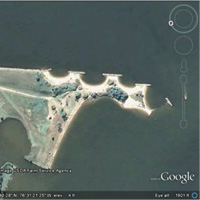
Potomac River, Westmoreland County, Virginia
Site Parameters
- Coast Type: Headland
- Body of Water: Potomac River
- Shore Direction of Face: East South East
- Shore Type: Spit/Marsh
- Average Shore Height:4 feet
- Average Fetch: 9 nautical mile
- Distance to 6ft Contour: 240 feet
- Date Installed: December 1989
- Type: Headland Breakwaters
Land Use: Residential
Ownership: Private
Problem: Severe erosion of low sandy spit as a result of sand source loss by updrift shoreline hardening
Project purpose: Shore protection, habitat enhancement and maintain spit feature that protects cove area in lee.
The site has a long fetch exposure to the southeast down the Potomac River and across the Bay of over 35 miles. Breakwaters with beach fill and a sill, which cover 800 ft of shore, were installed in 1989. The project consists of 3 headland breakwaters, beach fill and wetlands plantings along the Potomac River shore and a low sill on the back side on the Yeocomico River side to protect the spit. It was designed utilizing the 1:1.65 ratio of Bay indentation to Bay Gap relationship (Mb:Gb). The site has an open boundary on updrift project end and a breakwater spur on the distal end of the spit.