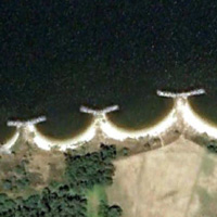
(PAT) Patuxent River Fuel Pier
Location:
Patuxent River, St. Mary's County, Maryland
Site Parameters
- Locality: St. Mary's County
- Body of Water: Patuxent River
- State: Maryland
- Shore Direction of Face: NNW
- Shore Type: Beach
- Land Use: Military
- Average Shore Height: 60 feet
- Coast Type: High Bank
- Type: Headland Breakwaters
- Average Fetch: 6 miles
- Distance to 6ft Contour: 300 ft.
- Number of Breakwaters: 4
- Number of Bays: 3