Shoreline Management Model – SMM
The Shoreline Management Model (SMM) is a geospatial data model run in ArcGIS that recommends strategies for tidal shoreline erosion control. Available information about shoreline conditions is processed through decision flow charts to reach shoreline stabilization recommendations, including where living shoreline approaches may be suitable. Model output can be viewed and analyzed with interactive map viewers.
Shoreline conditions factored in the Shoreline Management Model v6.0 include:
- Bank Height
- Bank Slope
- Beach
- Tidal Marsh
- Submerged Aquatic Vegetation (SAV) or Mangroves
- Wave Energy
- Nearshore Bathymetry
- Canals (navigable)
- Proximity to Narrow Creeks
- Federal Channels
- Tributary Designation
- Sand Spits
- Fetch
- Permanent Structures
- Public Boat Ramps
- Riparian Land Use
- Agricultural Areas
- Roads
- Shoreline Protection Structures
- Rare Threatened Endangered Species
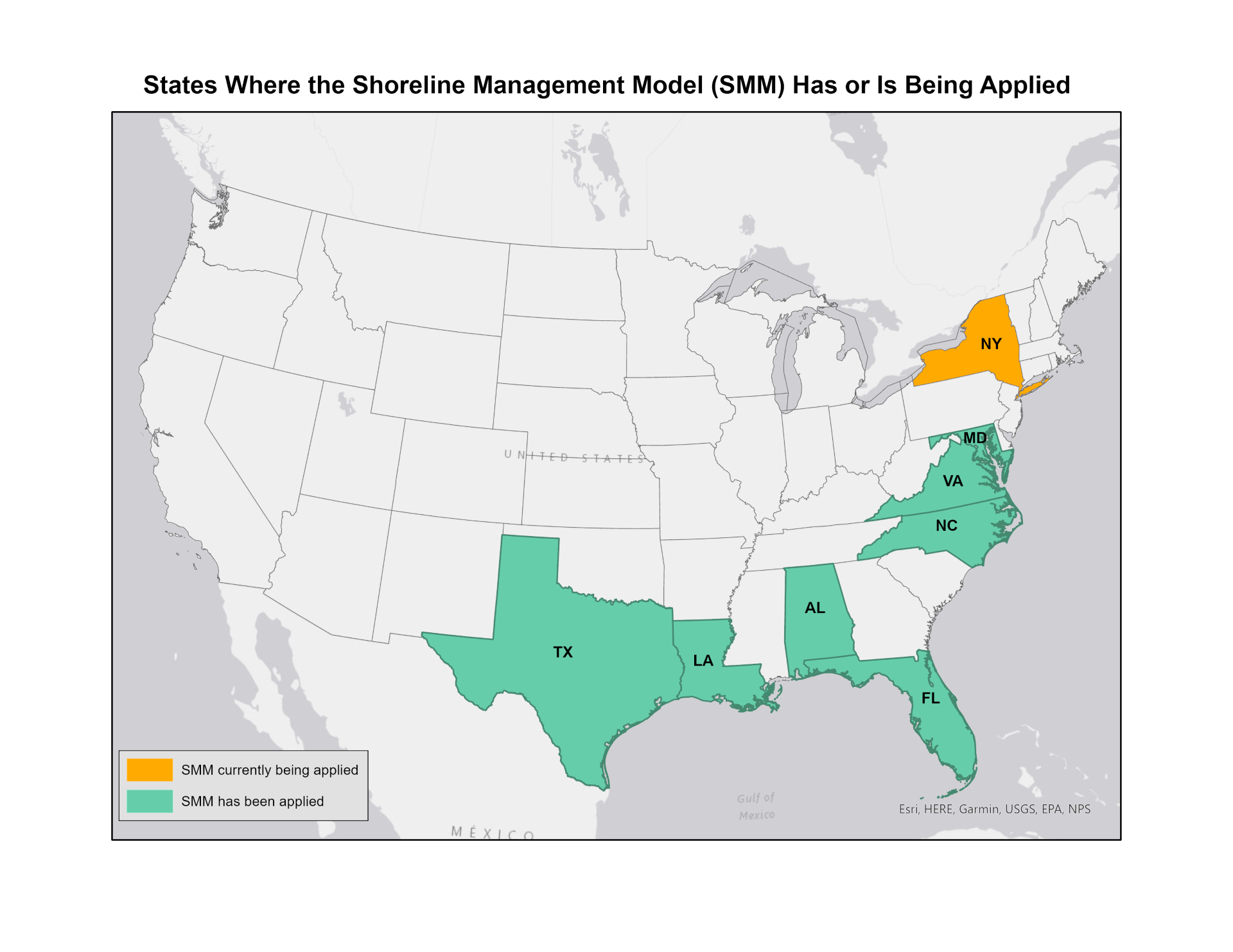
Regional Shoreline Management Models
The SMM was originally developed for coastal Virginia with several version updates. This model has been customized for application in other coastal regions of the United States.
Virginia |
MarylandThe Maryland Shoreline Stabilization Mapper (MSSM) was developed in collaboration with the Maryland Department of the Environment. This interactive map viewer displays results from the Maryland Shoreline Stabilization Model along with Special Consideration Layers. Visit MDE Living Shoreline Resources for more information about using this tool. |
TexasThe Texas Living Shoreline Site Suitability Model was developed by the Harte Research Institute at Texas A&M University – Corpus Christi from the original VIMS shoreline management model foundation. This model tool is made available through the Texas General Land Office Clean Coast Texas program and a related Guide to Living Shorelines in Texas. Shoreline conditions factored into the Texas Living Shoreline Site Suitability Model include:
|
Florida – Tampa BayThe Living Shoreline Suitability Model for Tampa Bay was developed in 2018 by the Florida Fish and Wildlife Conservation Commission Fish and Wildlife Research Institute from the original VIMS shoreline management model foundation. This model tool is made available through a Living Shorelines Story Map and web site. Shoreline conditions factored into the Tampa Bay Living Shoreline Suitability Model include:
|
Louisiana - Lake PontchartrainThe Lake Pontchartrain, LA Living Shoreline Site Suitability and Decision Making Tool was developed by Troy University and LA Sea Grant from the original VIMS shoreline management model foundation. This model tool is made available through an online interactive map viewer. |
Alabama – Mobile Bayhttps://www.mobilebaynep.com/assets/pdf/Living_Shorelines-12.15.16-Web.pdf |
Alabama & Florida – Pensacola Bay / Perdido Bay / Wolf Bay / Ono Island ComplexA living shoreline site suitability model and master plan for the Pensacola Bay System is in progress by Santa Rosa County and the Pensacola & Perdido Bays Estuary Program. The project will assess 175 miles of shoreline to characterize and prioritize living shoreline opportunities across local government jurisdictions as a comprehensive coastal resilience strategy. |
North Carolina - Pamlico CountyThe Shoreline Management Model version 5.1 has been run in Pamlico County, NC, to identify areas suitable for living shorelines. - North Carolina Sea Grant.
|
If you are interested in applying the SMM v6.0 model in your region, please contact Karinna Nunez at karinna@vims.edu.
Related Links
- Nunez, K., Mason, P., Rudnicky, T., Tombleson, C., Duning, C., Hendricks, J., Lv, M., Hill, E., Graulich, J., Schatt, D., & Duhring, K. (2026). Advancing the use of spatial data in implementing adaptive management to support coastal resilience. In C. Coelho, C. Hallin, F. Sancho, & P. A. Silva (Eds.), Coastal Dynamics 2025 (Vol. 1, pp. 284–290). Springer. https://doi.org/10.1007/978-3-032-15473-6_45
- Nunez, K., Rudnicky, T., Mason, P., Tombleson, C., Berman, M. (2022). A geospatial modeling approach to assess site suitability of living shorelines and emphasize best shoreline management practices. Special Issue: Nature-based coastal defense: developing the knowledge needed for wider implementation. Ecological Engineering. 179. 106617.
- Tidal Shoreline Inventories shoreline conditions map used for model input
This model has been funded, in part, and at various stages, by the VIMS' Center for Coastal Resources Management, the NOAA RESTORE Science Program, and NOAA's Coastal Zone Management Program in Virginia.