ShoreWatch
![]()
ShoreWatch Registration - ShoreWatch is Officially Launched!
ShoreWatch is a GIS-based application used to collect standardized monitoring data on living shorelines. A seamless integration of ArcGIS FieldMaps and Survey 123, ShoreWatch allows users to geolocate living shoreline features through GPS location and capture changes in living shoreline sites over time. ShoreWatch provides the ability to collect consistent monitoring data to assess living shoreline project performance.
Living shoreline professionals, your opportunity to monitor and collect standardized shoreline data is here! The app is free to use, but registration is required.
Register today and start contributing to shoreline monitoring data!
Important: After October 30, 2025, ALL users must register to access ShoreWatch, as the universal 'VIMSShoreWatch' credentials will be retired.
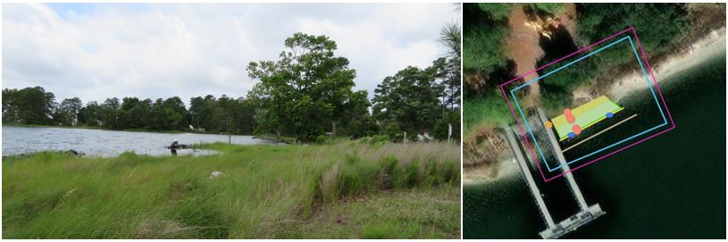
Monitoring Living Shorelines with ShoreWatch
Whether users are interested in monitoring living shorelines to achieve reporting requirements or want to simply track observable ecosystem changes like vegetation establishment and oyster growth, ShoreWatch captures a variety of key system metrics through scientifically-based monitoring guidelines. Monitoring techniques were designed to be low-cost, requiring only basic equipment and materials. External GPS units for enhanced accuracy can be loaned out to users by the ShoreWatch Team at CCRM.
ShoreWatch Data Explorer
The ShoreWatch Data Explorer is an interactive dashboard where user groups can access and analyze their monitoring data collected with ShoreWatch. The dashboard displays trends for key metrics of monitored sites to easily view changes within the living shoreline. Users can also generate reports from the Data Explorer to assess project performance across their living shoreline sites.
ShoreWatch Data Management Plan
References
Living Shoreline Monitoring Protocol Manual details monitoring metrics and procedures with ShoreWatch.
ShoreWatch User Guide provides step-by-step instructions for using ShoreWatch.
Bad Elf GPS Receiver how to operate the Bad Elf GPS unit with ShoreWatch.
Additional Documents
VA Salt Marsh Plants Field Guide
Living Shoreline Treatment Types and Glossary
Training Materials
Introductory Training Slide Deck
AcknowledgmentsThe Living Shoreline Monitoring ShoreWatch App and manuals were developed by a team from the Center for Coastal Resources Management (CCRM) at Virginia Institute of Marine Science, including – Christine Tombleson (App Creator), Jessica Fergel and Sean Gregory (lead authors of the manual and appendix material), Karen Duhring, David Stanhope, Kory Angstadt, and Donna Marie Bilkovic. Early versions of the App were informed by discussions with James River Association, Shoreline Erosion Advisory Service (SEAS) and Living Shoreline Collaborative members, and we thank them for lending their time and expertise, including Shereen Hughes, Stacie McGraw, Aaron Wendt, Ashley Kipp, Kati Grigsby, Jameson Brunkow, Ella DiPetto, Lucy Deignan and Ryan Walsh. The ShoreWatch Data Explorer (interactive dashboard) was developed by CCRM team members Jess Hendricks and Christine Tombleson. Partial funding support for ShoreWatch was provided by the National Fish and Wildlife Foundation (#0602.20.068098) with a subaward issued by the primary recipient James River Association, and the Environmental Protective Agency (CD95340801). |