
Molluscan Ecology Monitoring & Advisory
The monitoring data that we collect is used to help guide fisheries management and the industry as well as to assess the effects of restoration efforts.
Programmatically, we have been in the business of monitoring Virginia’s oyster resources since the 1940s. Since 1993, a collaborative agreement with the Virginia Marine Resources Commission (VMRC) Conservation and Replenishment Department has led to continued oyster monitoring as well as oyster stock assessment and restoration activities throughout Virginia waters. Annual summaries are presented to the Shellfish Management Advisory Committee (SMAC) as part of the ongoing resource management process. Current monitoring efforts include:
Oyster Dredge
This survey has been conducted annually in the fall since the 1940s and has been a collaborative effort between VIMS and VMRC since the
Oyster Patent Tong
This survey has been conducted annually in the fall since 1993 in collaboration with VMRC. The patent tong survey is a quantitative survey that provides information about
Oyster Shellstring (spatfall ):
The shellstring survey has been conducted annually from late spring through early fall at various sites throughout Virginia’s western Chesapeake Bay tributaries since the early 1940s. The survey provides an estimate of a particular area’s potential for receiving a “strike” or settlement of oysters on the bottom and helps describe the timing of settlement events in a given year. This data can be used by parties interested in potential timing and location of shell plantings.
Virginia Oyster Productivity Information Tool (best viewed in Firefox or Safari browser)
The most rapid expansion of the aquaculture industry in Virginia has been in hatchery-based production of cage-cultured oysters on private grounds. Conflicts have arisen between new user groups residing along the Chesapeake Bay shore, and a growing industry that works primarily in nearshore waters. Additionally, as the shoreline has been developed, there are very limited access points along the waterfront where commercial activity can occur. This study has characterized the oyster industry as it exists today, examined the regulatory framework, and closely examined major issues that impact future expansion.
See VIMS article: New Interactive Tool Visualizes Virginia's Oyster Populations
VOSARA
The Virginia Oyster Stock Assessment and Replenishment Archive (VOSARA - old version) data website is designed to provide graphic summaries of the status of oyster stocks in the Virginia subestuaries of the Chesapeake Bay through 2024. After this date the summaries have discontinued in the tabular and bar chart format, and have been replaced with a new GIS format (see below). Data originates from the patent tong survey. Summaries provide data by year and historical reef boundaries within each of the described subestuaries. Oyster populations are described in units of density, oysters per unit area, for each of three size classes: spat are young of the year, small are submarket size (<76 mm length), and market size (>76 mm length) oysters.
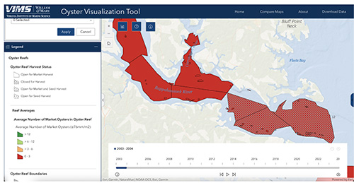
The Virginia Oyster Stock Assessment and Replenishment Archive (VOSARA 2.0) is a new data website designed to provide summaries of the status of oyster stocks in the Virginia subestuaries of the Chesapeake Bay using an interactive GIS format. The site includes all historical data from the former VOSARA website, plus additional categories, the ability to display multiple categories simultaneously and a time slider facilitating view of the time series data. As with VOSARA, data originates from the patent tong survey. Summaries provide data by year and historical individual reef boundaries and management area boundaries within each of the described subestuaries. Oyster populations are described in units of density; oysters (spat, small market), biomass and brown shell volume per unit area. Annual replenishment activity as well as harvest status (open, closed, gear type) is also included. Disease status (MSX and Dermo prevalence) is provided on a subset of the reefs.